
Photographs © Ross Gordon
America's natural beauty is disappearing right before our eyes. Land Trusts such as River Fields are protecting the best before it is too late. — Rand Wentworth, President of the Land Trust Alliance
History of Ohio River Corridor
Cedar Hill Farm. Courtesy River Fields, Inc.
The Ohio River was one of the most important transportation corridors in 18th and 19th century America. The Falls of the Ohio, the only Devonian fossil bed in North America, required travelers to leave their boats and portage around the falls. This created commercial opportunities that led to settlement and, eventually, to the city of Louisville. The Ohio River watershed is now a diverse collection of historic farms, buildings, towns and settlements set in a landscape that include waterfalls, wetlands, streams, and a diversity of federally endangered plant species. The watershed encompasses Oldham, Jefferson, and Hardin Counties in Kentucky and Jefferson, Clark, Floyd, and Harrison Counties in Indiana.
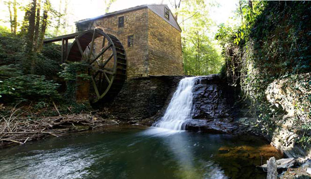
Significant properties along the watershed are varied and expansive. The 412-acre Wolf Pen Branch Mill Farm dates to the early 1800s when the original gristmill was built. The 175-acre Cedar Hill Farm (c.1830) has been cultivated for more than 150 years and is home to several of the earliest brick and stone buildings in Oldham County. The circa 1790 Edwards–Herr House is one of the earliest brick structures in Jefferson County and reflects the prosperity of its residents, one of Louisville’s founding families. Wildwood Farm, home to wealthy tobacco manufacturer, Woodford Fitch Axton, continues to host the 1920s rusticated limestone, Colonial Revival residence that was the center of activity on the “Gentleman’s Farm.” The landscape at Edyalmoor dates to the region’s late 18th century settlement when it was established as one of the area’s largest plantations. After several owners and subsequent subdividing of the property, the designed landscape on the 18-acre estate includes a formal evergreen garden and contributions from the Olmsted Brothers firm’s James Frederick Dawson.
Founded in 1959, River Fields, Inc. is one of the nation’s oldest river conservancies. The focus of its mission is protection of a 50-mile stretch of the Ohio River between Westport and West Point, Kentucky, including its diverse cultural and natural resources. River Fields began as an advocacy organization that sought to preserve solely scenic and natural values, by encouraging appropriate planning and advocacy before state and local regulations were established. Within a few decades, the group began acquisition of real property as another tool for protection.
Twenty-five years ago, Meme Sweets Runyon became River Fields’ Executive Director. Under her leadership, the organization broadened its mission to include advocacy for cultural as well as natural and scenic values. She has accomplished this in a number of ways. River Fields has expanded its vision to include the protection of the cultural environment and the ability to accept conservation easements on tributaries within the geographic boundaries of River Fields’ mission. River Fields now holds nearly 2,200 acres in conservation easements, much of which is either listed in the National Register of Historic Places or is potentially eligible. All five of the sites noted are protected by conservation easements jointly held by River Fields and the Kentucky Heritage Council, and are listed in the National Register, with four listing both their architectural features and cultural landscape. With an understanding of River Fields’ professional limits in the field of historic preservation, Ms. Runyon conceived of the idea of joint easements in concert with the State Historic Preservation Office.
In partnership with the urban county and the local sewer district, Ms. Runyon has also been instrumental in the conceptual development, preparation, and adoption of the Ohio River Corridor Master Plan, a comprehensive development plan for the 37-mile Ohio River Corridor in Jefferson County, Kentucky.
Wildwood Farm. Courtesy River Fields, Inc.
Threat
In recent years, there has been a surge in suburban sprawl along the Ohio River Corridor. This has resulted in massive transportation projects attempting to deal with the influx of development. During a 20-year period in the Louisville metropolitan area, the population only grew 6%, however, in those same years, developers converted 60% of the land and open space to housing and commercial development. Existing local planning and zoning regulations are not well-equipped to address the increase in development and are increasingly being neglected as unchecked development continues to take place. The result of this sprawl is that historic properties protected by Federal laws, such as the National Historic Protection Act, risk losing their equally significant landscape context, or setting, because the surrounding “natural” landscape is often not protected.

