Landscape Information
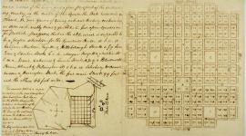
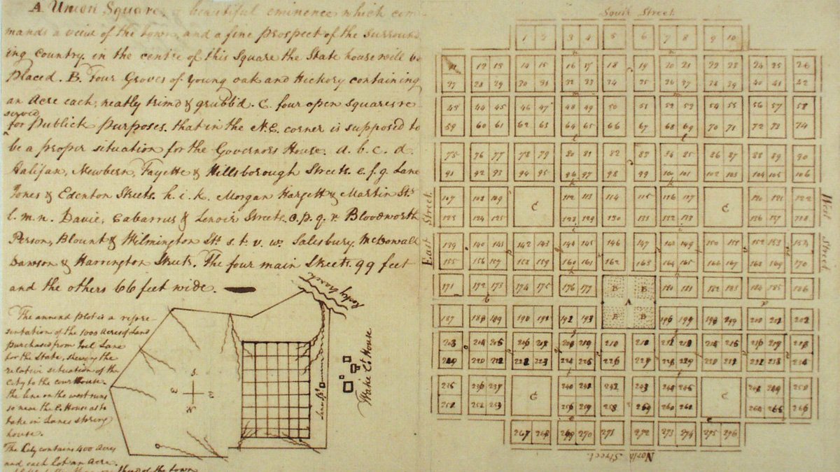
Following the Revolutionary War, the North Carolina General Assembly resolved to situate a permanent capital in a central location. In 1792 a thousand-acre plot of thickly forested farmland was purchased from local landowner Joel Lane, and surveyor and former North Carolina state senator William Christmas was hired to develop the plan for the city. Christmas modelled his design after William Penn’s Philadelphia Plan, creating a one-square-mile grid of perpendicular streets with integrated green space, centered on Union Square (now Capitol Square), which was designated as the site of the State Capitol building. Four 99-foot-wide thoroughfares acted as the main arteries: Fayetteville, Halifax, Hillsborough, and New Bern Streets. Each of the city’s quadrants contained a four-acre square with public green space, named after state leaders Richard Caswell (northwest of Union Square), Thomas Burke (northeast), Alfred Moore (southeast), and Abner Nash (southwest). Each featured diagonal pedestrian pathways, lawns, and commemorative elements, including statuary and civic art.
The Christmas Plan remained largely unchanged until after the Civil War, when Raleigh saw significant growth. Despite substantial expansion in recent decades, downtown Raleigh retains much of Christmas’ original street grid. Though Burke Square now contains the Governor’s Mansion, and Caswell houses government buildings and is no longer discernable as an open square, both Moore and Nash Squares continue to function as public parks. To the north of the Capitol, Bicentennial Plaza and Halifax Mall retain the footprint of the original Halifax Street. Capitol and Moore Squares, and their neighboring streets, were listed in the National Register of Historic Places as the Capitol Area Historic District in 1978 and the Moore Square Historic District in 1983.