
City Shaping: The Olmsteds & Louisville
During your trip, you will have resources to help you understand how the designs of Olmsted and his firm shaped the city for future generations.
- The Visitor Guide organizes the application by topic. Make a choice in the Visitor Guide to go to the location of that information in the application.
- The Map gives an overview of Louisville and offers a panoramic tour of the park system.
* Flash 7 + required to use this application. Get Plugin
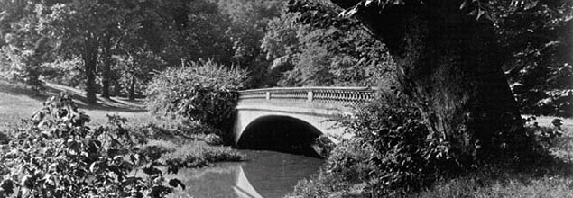
The network of parks and parkways for Louisville, KY designed by Frederick Law Olmsted, Sr., and his son, John Charles Olmsted, was the last park system of the elder Olmsted's fifty year career.
This interactive documentary is designed to let you travel through the system on your own to learn about that important cultural landscape.
![]()
Project Credits
DIRECTOR / PRODUCER
|
CONSULTANTS
|
![]()
![]()
Cultural Landscapes as Classrooms project has been supported with grants from The National Endowment for the Arts Design Arts program and the Max and Victoria Dreyfus Foundation. The American Society of Landscape Architects (ASLA) is a partner in TCLF's Cultural Landscapes as Classrooms series and has provided in-kind support.
City Shaping: The Olmsteds & Louisville was supported with a generous gift from the Rudd/McClure Joint Ventures.
Photographs, prints and drawings reproduced courtesy of the following individuals and institutions: Bentley Koepke Inc., John Beckman/Quadrant, Charles Birnbaum, Environs/Inc., Arleyn Levee, Library of Congress, Louisville Courier-Journal, Louisville Metro Housing Authority, Louisville Olmsted Parks Conservancy Archives, Louisville Waterfront Development Corporation, Kentucky Educational Television, Kentucky Virtual Library , Frederick Law Olmsted National Historic Site, James Sheldon, Michael Smiley, The Filson Historical Society, University of Louisville Photographic Archive, Shirley Veenema, Ted Wathen/Quadrant.
Individual images, video, texts, and Flash objects copyrights held by the individuals and institutions, as identified on each object page in the archive.
The Producers wish to acknowledge and thank its project collaborators, Louisville Olmsted Parks Conservancy, Louisville Metro Parks, and Louisville Metro Government. Special thanks to Shaun Duncan and Victoria Williams (Cultural Landscape Foundation), and Carolyn Smither and Darlene Yann (Louisville Olmsted Parks Conservancy) for assistance; and Louisville Metro Parks for base images used in maps.
Copyrighted mapping data provided by Louisville/Jefferson County Information Consortium. ![]()
City Shaping: The Olmsteds & Louisville ©2006 The Cultural Landscape Foundation