


Landscape Information
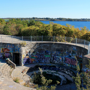
Overlooking Narragansett Bay and perched on 100-foot-high cliffs at the southeastern tip of Conanicut Island, this site is historically significant for its role as a military outpost. Though American colonists intended to fortify the strategic location in advance of the Revolutionary War, it was seized by British troops and occupied until 1779. Nineteen years later, French military engineer Major Louis Tousard constructed a stonework fortification and tower called Fort Dumpling occupying one-third of an acre on one of the island’s southerly granite outcroppings. At the outbreak of the Spanish-American War 100 years later, the romanticized ruins of the tower were destroyed and the property was enlarged. Re-named Fort Wetherill in 1900, several massive, concrete gun emplacements—part of a network of modernized seacoast defenses—were constructed behind thick earthen embankments and camouflaged with vegetation. Ammunition storehouses, tunnels, communications towers, and other buildings were also eventually built. Utilized primarily for training and submarine equipment, the fort was active during World Wars I and II, closing in 1946.
In 1972, the same year Fort Dumpling was listed in the National Register of Historic Places, the State of Rhode Island acquired the 61.5-acre site for use as a state park. New roads were laid out to follow the historic routes developed by the military and several meandering trails branch from these, passing through undergrowth and brambles to access rocky cliffs and remnant architecture. Crumbling gun embankments, bunkers, and tunnels attract visitors who also make use of the park for picnicking, hiking, boating, fishing, and scuba diving.