Landscape Information
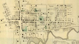
Measuring 1.52 square miles (979 acres), this community lies approximately one-and-a- half miles east of the Hudson River on a relatively flat plain. Situated just north of the Landsman Kill, the historic district incorporates 249 acres of the village. Its origins can be traced to the early eighteenth century, when William Traphagen established a home and tavern at the crossroads of two thoroughfares (now Route 9 and Market Street). Around 1714, 35 German Palatine families settled nearby land provided by Henry Beekman. Bolstered by the proximity to the Hudson River, inland trade routes, and a reliable source of waterpower, Rhinebeck emerged as an agricultural and manufacturing center by the mid-nineteenth century.
Today, Rhinebeck’s historic core remains centered at its historic crossroads which has evolved to become a contemporary commercial district. Residential streets generally parallel Route 9 and Market Street and extend from the village center. The linear streets are bordered by sidewalks and lawn verges planted with deciduous shade trees, including locust and maple. The community features numerous historic buildings, including an eighteenth-century inn, churches, commercial buildings, and residences, which showcase a range of architectural styles, among them Colonial, Federal, Greek Revival, Hudson River Bracketed, Victorian, and Queen Anne.
The approximately twelve-acre Legion Memorial Park lies near the southern edge of the district along the Landsman Kill, which was dammed to form Crystal Lake. The water feature includes two islands and was used at the turn of the twentieth century as a recreational and commercial amenity. The land was donated to the American Legion in the 1950s as a memorial to veterans and a walled, stone seating area was constructed west of the lake facing Route 9. The Rhinebeck Village Historic District was listed in the National Register of Historic Places in 1979 and its boundary was increased in 2020.


