Mapping Kiley – the Dan Kiley Built Works Index
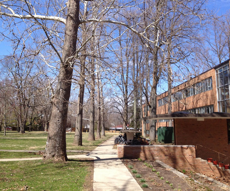
 Battle Green Apartments, Lexington, Massachusetts, photo courtesy Kris Lucius
In Kiley's work I've always been drawn by the raw spatial power of his plantings. When I was first learning about designed landscapes his pure volumes were the most immediate for me; the first landscapes that I could recognize abstract ideas in. Over time the magic of his landscapes have only become more nuanced for me, and I've been consistently inspired by his use of shade, repetition, and the little details like which elements align and which overlap. – Kris Lucius, 2014

Kris Lucius with his son at Birch Hall, Antioch College,
Yellow Springs, Ohio, photo courtesy Kris Lucius.
After moving to Massachusetts in 2004, landscape architect Kris Lucius started spending his weekends traveling to designed landscapes around Boston and New England. Nurturing a love for the work of landscape architect Dan Kiley (1912-2004), he began to focus his travels on visiting the local works of this significant Modernist designer many of whose commissions are little known. An important resource for Lucius is Dan Kiley and Jane Amidon’s 1999 book Dan Kiley: The Complete Works of America’s Master Landscape Architect (the most complete compendium of Kiley’s work) though the vast majority of the projects listed are denoted only by a single line containing the site’s name, year of completion and location.
Hoping to expand on Kiley and Amidon’s list Lucius created the Dan Kiley Built Works Index to precisely locate and map every known, built Kiley design. The scope of this mapping research project is immense—it has been estimated that two-thirds of Kiley’s 1,300 projects were built—and most of the sites require detective-like puzzle solving to find and piece together the scraps of information that exist. Moreover, an important portion of the Kiley archives was lost in a fire, making Lucius’ quest more challenging.
In order to map the projects Lucius consults an expansive array of sources including academic archives, architectural monographs, city directories, tax records, obituaries, and other ephemara. Sometimes information leads only to a neighborhood or general area, in these situations online aerial photography is manually scanned for the telltale geometries of a Kiley landscape. For many of the sites it isn’t conclusive from aerials or Google Street View whether Kiley’s work remains, or was even built. For these situations the map pin acts as a bookmarker and, with any luck, a call for input to anyone viewing the map. Green pins indicate built projects, while blue dots indicate sites with biographical significance, such as homes that Kiley lived in or schools that he attended.

The Dan Kiley Built Sites Index
While still a work in progress, Lucius’ map has fulfilled its initial objectives to act as a guidebook for visiting Kiley’s work. Where possible, he has made a point of visiting and photographing those previously unknown, publicly accessible projects and presenting these new discoveries to Kiley enthusiasts and the general public. Among them:
- Birch Hall and Commons at Antioch College in Yellow Springs, Ohio. Working with Eero Saarinen, this was one of Kiley’s first projects in the Midwest, where he used native tulip poplars and sycamores to harmonize the modern building nested within an existing, pastoral campus.
- Battle Green Apartments in Lexington, Massachusetts. This small, 1964 neo-colonial apartment complex is a curious outlier from an era when Kiley was working with the avant-garde of Modernism. While understory plantings have changed since it was designed 50 years ago, the boxes of 50-year-old maples form bold spaces that bear the mark of Kiley’s input, if not his hand.
- Brook House Apartments in Brookline, Massachusetts. Working in collaboration with Washington, D.C. architect Chloethiel Woodard Smith, Kiley provided landscape design for this massive development of housing towers and elevated terraces over parking decks at the edge of Olmsted’s Emerald Necklace.

Birch Hall and commons, Antioch College, Yellow Springs, Ohio, photo
courtesy Kris Lucius.
Lucius, who practices with SmithGroupJJR in Chicago, is mapping these sites state by state, and to date has pinned 59 sites in Massachusetts, Ohio, and Illinois. He plans to update the map with four to five states per month, and expects to have all known work mapped by autumn 2014. The map is publicly accessible online, with links to aerial photography, site photos, and Web-based resources. Lucius hopes that Kiley associates, clients, consultants who worked with him, and anyone else who can corroborate, negate, or otherwise expand upon the mapped sites will see the project. The fully realized project will be an important addition to the corpus of information about the life and legacy of this pioneering and profoundly influential Modernist landscape architect.


