Trump Administration Reduces Protections for Bears Ears National Monument
A federal management plan unveiled on July 26, 2019, by the U.S. Bureau of Land Management (BLM) and Forest Service defines the priorities and guidelines for the Bears Ears National Monument, located in southeastern Utah’s San Juan County. The far-reaching 800-page document could adversely impact the wilderness area because it allows for clearing pinyon and juniper forests that are essential for fire management, and it would permit all-terrain-vehicle (ATV) trails to be built in the Indian Creek Area, and utility lines to be erected. The new management plan is based on an adjusted version of one of four proposals released last year. Notably, it offers fewer protections than the resource management plan that was developed for the area before it was designated a national monument.

Despite strong bipartisan support for maintaining the monument, in 2017 President Donald Trump reduced its area to 202,000 acres—just fifteen percent of its original size. In response to a 2015 petition from the Bears Ears Inter-Tribal Coalition, President Barack Obama declared Bears Ears a national monument in 2016.
According to the Salt Lake Tribune, a local news source, the Trump Administration’s plan includes new features under the rubric of “Alternative E,” which “will not manage inventoried lands with wilderness characteristics specifically to protect wilderness characteristics,” thereby providing few restrictions on recreational activities such as target-shooting, off-road vehicle usage, camping, building campfires, and rock-climbing. Moreover, monitoring is mandated to occur only annually, and mitigation measures would occur only if fossil resources are affected—a potentially illegal measure that violates Section 6302 of the Paleontological Resources Preservation Act (PRPA). The new plan comes as some areas of the monument have been reopened to drilling and mining. Moreover, much of the land reclaimed from the monument no longer remain under the jurisdiction of the BLM or Forest Service.

The plan’s release brought widespread condemnation from environmental and scientific groups. According to Chris Winter, executive director at Access Fund, a local recreational group, “The BLM’s plan is premature and unlawful because it ignores 85 percent of the public lands included in the original proclamation. For the remaining 15 percent, BLM has kicked the can down the road and put off critical recreation management decisions that are needed now to protect and uphold the values that led to the monument designation in the first place.” Katherine Malone-France, chief preservation officer at the National Trust for Historic Preservation, said that the plan clearly falls short of providing proper stewardship for a culturally significant landscape:
It completely lacks appropriate measures to ensure protection of the significant cultural and historic resources that prompted the national monument designation in the first place and appears to leave the resources with even less protection than they had before the monument was designated. We will continue to push for the restoration of the Bears Ears National Monument to its original boundaries, and for a comprehensive management plan that truly protects the resources on the land that tell the stories of more than 12,000 years of human history.
TCLF featured Bears Ears National Monument in its Landslide 2017: Open Season on Open Space when President Trump issued an Executive Order requiring then-Interior Secretary Ryan Zinke, whose purview included the Antiquities Act, to reassess the status of 27 national monuments, including Bears Ears. In short, the president wished to explore options for rescinding the protected status of some monuments and/or redrawing their boundaries to accommodate energy extraction in fulfillment of a campaign promise to increase mining and oil-and-gas drilling. The size of the Bears Ears monument was subsequently reduced.

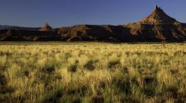
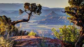
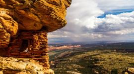
Five Native American Tribes— the Navajo Nation, Hopi, Ute Mountain Ute, Zuni, and Ute—petitioned President Obama to create the monument, originally covering some 1.35 million acres. The monument was bordered by the Colorado and San Juan Rivers to the west, the Navajo Reservation to the south, low bluffs and high mesas to the east and north, and Canyonlands National Park to the northwest. At the center, the Bears Ears Buttes tower above Cedar Mesa, a vast plateau with twelve canyons folding along its sides. Mule deer, elk, bighorn sheep, Utah’s only population of Albert’s tassel-eared squirrels, and numerous other species live among pinyon-juniper woodlands and canyons of yucca and cacti within the monument’s boundaries. With its large-scale petroglyphs, the mostly roadless site records Native American lifeways and continues to support traditional events, such as medicinal and ceremonial plant collection.
The five Native American tribes, along with several conservation groups, have sued the Trump Administration over the reduction of the monument. If the lawsuits are successful, the new management plan would be moot.
Related Content
Bears Ears National Monument
Monticello, UT